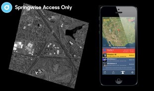
Given the recent flurry of hacking scandals over the last few years, it’s no surprise that consumers are now more concerned with their privacy than ever. Predictably, this has given rise to a number of startups looking to calm/capitalise on that fear, such as a clothing range designed to prevent phones from being hacked. For users that are unnerved by the thought of satellites — such as ones used by Google Maps — taking photographs of their house or themselves, now a new satellite-tracking app may provide some comfort. Created by Orbit Logiv Inc., an organization specializing in supplying software to the aerospace and intelligence communities, SpyMeSat is a mobile app which notifies users when a satellite is flying above their heads and potentially taking their picture.
SpyMeSat’s sources include orbit data from the North American Aerospace Defense Command, and other publically available data dealing with commercial and international imaging satellites. It works by notifying users when satellites are flying above their heads, and may be taking photographs of them. It features a dynamic map which shows orbit tracks, and the location of remote sensing satellites that have upcoming passes over a user’s specified location. Users can learn about each imaging opportunity, as well as browse information on specific satellites. For example, a user could investigate which nation owns the satellite, and which company is responsible for its manufacture. There is also the option of modifying the location of interest, and setting up notifications for specific locations.
SpyMeSat is the company’s first product that is accessible for users beyond their regular customer base of aerospace, defense and government intelligence personnel. What other industry-specific tools can be democratized to allow the everyday user access?
Website: www.spymesat.com
Contact: spymesat@orbitlogic.com


